|
Lectures: Patagonia, Iceland, Lichens and more! ͏ ͏ ͏ ͏ ͏ ͏ ͏ ͏ ͏ ͏ ͏ ͏ ͏ ͏ ͏ ͏ ͏ ͏ ͏ ͏ ͏ ͏ ͏ ͏ ͏ ͏ ͏ ͏ ͏ ͏ ͏ ͏ ͏ ͏ ͏ ͏ ͏ ͏ ͏ ͏ ͏ ͏ ͏ ͏ ͏ ͏ ͏ ͏ ͏ ͏ ͏ ͏ ͏ ͏ ͏ ͏ ͏ ͏ ͏ ͏ ͏ ͏ ͏ ͏ ͏ ͏ ͏ ͏ ͏ ͏ ͏ ͏ ͏ ͏ ͏ ͏ ͏ ͏ ͏ ͏ ͏ ͏ ͏ ͏ ͏ ͏ ͏ ͏ ͏ ͏ ͏ ͏ ͏ ͏ ͏ ͏ ͏ ͏ ͏ ͏ ͏ ͏ ͏ ͏ ͏ ͏ ͏ ͏ ͏ ͏ ͏ ͏ ͏ ͏ ͏ ͏ ͏ ͏ ͏ ͏ ͏ ͏ ͏ ͏ ͏ ͏ ͏ ͏ ͏ ͏ ͏ ͏ ͏ ͏ ͏ ͏ ͏ ͏ ͏ ͏ ͏ ͏ ͏ ͏ ͏ ͏ ͏ ͏ ͏ ͏ ͏ ͏ ͏ ͏ ͏ ͏ ͏ ͏ ͏ ͏ ͏ ͏ ͏ ͏ ͏ ͏ ͏ ͏ ͏ ͏ ͏ ͏ ͏ ͏ ͏ ͏ ͏ ͏ ͏ ͏ ͏ ͏ ͏ ͏ ͏ ͏ ͏ ͏ ͏ ͏ ͏ ͏ ͏ ͏ ͏ ͏ ͏ ͏ ͏ ͏ ͏ ͏ ͏ ͏ ͏ ͏ ͏ ͏ ͏ ͏ ͏ ͏ ͏ ͏ ͏ ͏ ͏ ͏ ͏ ͏ ͏ ͏ ͏ ͏ ͏ ͏ ͏ ͏ ͏ ͏ ͏ ͏ ͏ ͏ ͏ ͏ ͏ ͏ ͏ ͏ ͏ ͏ ͏ ͏ ͏ ͏ ͏ ͏ ͏ ͏ ͏ ͏ ͏ ͏ ͏
Wayne Roderick Lectures: Patagonia, Iceland, Lichens and more Wildcat Creek Erosion Control Project Watching Our Watershed: Community Science on Wildcat Creek January Plant Sales at the Garden Free Garden Tours - See What’s Blooming This Month
Photo: Lichens and mosses in the Botanic Garden by Sandy Steinman.
|
Wayne Roderick Lecture SeriesThe Wayne Roderick Lecture Series takes place on Saturday mornings starting at 10:30 a.m. in the Botanic Garden Visitor Center auditorium. These presentations are free and open to the public and are enjoyable for beginners and professionals alike.
|
|
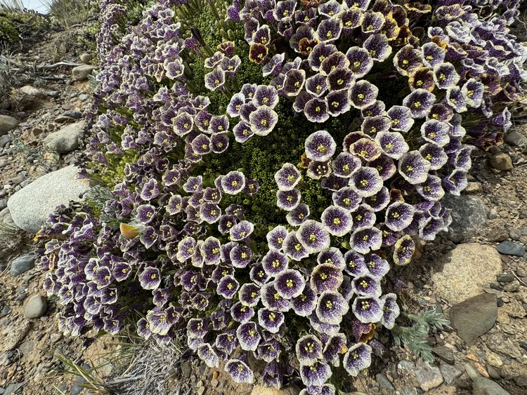
January 3: Patagonian Botanic Highlights. Bart O’Brien, Regional Parks Botanic Garden (RPBG) Director, will show highlights from his trip to Patagonia. Photo: Patagonian petunia (Fabiana patagonica) by Bart O’Brien. |
|
|
|
January 10: Images and Tales from Iceland. RPBG docent Laura Miller will recount her recent Iceland adventure. January 17: The Watershed Project: Wildcat Creek and More. Ethan Rayner, Restoration and Volunteer Manager at the Watershed Project, will talk on the current Wildcat Creek study (see article below). January 24: Species and Speciation. Ben Anderson, RPBG gardener, will address the evolution of botanic diversity. January 31: Lichens. Dr. Klara Scharnagl, Jepson Herbarium Curator of Lichenology, will provide an introduction to the lichens around us. See the full list on the Garden website.
|
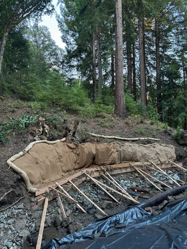
Wildcat Creek Erosion Control ProjectBy Bart O’Brien In late 2025, the Park District, Botanic Garden, and ETIC (the contractor) completed a sustainable erosion control project along a vulnerable northern section of Wildcat Creek. Designed by civil engineer Scott Stoller, the project utilized ecological restoration techniques rather than traditional concrete walls (as was done decades ago in the older parts of the Botanic Garden) to stabilize a steep slope threatened by high water flows. Project Implementation & Methods Bio-engineering: The slope was stabilized using overlapping bundles of native creek dogwood and willow stems, alongside upright willow “poles.” Material Sourcing: Willow materials were harvested from Tilden Park’s Lone Oak trailhead, while dogwoods were collected near Jewel Lake and within the Botanic Garden. Structural Support: Large rocks, gravel, and soil-filled felt bags were integrated to fill eroded gaps, providing a medium for roots to penetrate and further anchor the area. Post-Construction: The site received regular watering until the onset of winter rains and is now undergoing active monitoring to evaluate the success of these bio-engineering techniques.
Future Management and Environmental Changes Previous to this project, this part of Wildcat Creek was especially dark due to the large clumps of bay trees (Umbellularia californica). Many of the trees were failing due to heart-rot and other age-related maladies. Due to structural failures—including two separate instances in 2025 where falling trunks damaged a bridge and forced trail closures—additional bay tree removal is scheduled for 2026. These removals will significantly increase light levels, creating ideal growing conditions for the newly planted dogwoods and willows. All new plantings have been officially recorded in the Botanic Garden’s accession system.
|
|
Erosion control project during construction on October 11, 2025. Photos of the completed project are shown in the article below. Photo by Ethan Rayner. Bart O’Brien is the Director of the Regional Parks Botanic Garden. |
|
|
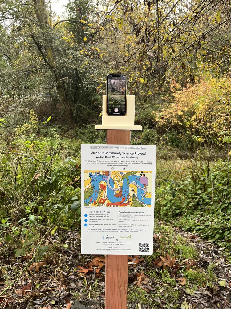
Watching Our Watershed: Community Science on Wildcat CreekBy Ethan Rayner Wildcat Creek changes constantly. In winter, it swells with stormwater pouring down from the hills. By late summer, certain stretches shrink to shallow pools or dry up entirely, exposing the creek bed. These seasonal shifts are natural, but understanding how and when they happen is essential to protecting our creek’s health. That is why The Watershed Project (TWP) is launching a new Wildcat Creek Water Level Monitoring (WLM) program rooted in community science, art, and public participation. Using simple phone-based monitoring stations installed at pedestrian bridges and other highly visible locations along the creek, community members are encouraged to take photos and upload them to our online database. Over time, these images help track water levels across seasons, building a clearer picture of how Wildcat Creek responds to rainfall, drought, and land use. Each station includes a small phone holder and interpretive sign with step-by-step instructions. Participants simply place their phone in the holder, take a photo, and upload it through TWP’s webpage. Submitted images will be curated and shared with the community to highlight seasonal and long-term changes.
|
|
|

|
Water Level Monitoring (WLM) station installed at the Rifle Ridge Trail bridge over Wildcat Creek. |
|
|
|
|
|
WLM station at the bridge downstream of Jewel Lake overlooking the spillway. Photo by River Allen. |
|

|
|
|
|
|
|
WLM station outside the Tilden Nature Area Environmental Education Center. Photo by River Allen. |
|
|
|
|
|
WLM station installed at the Regional Parks Botanic Garden. |
|

|
|
|
|
|
Each water level monitoring sign also features original artwork by local East Bay artists, adding a creative layer to the program. The artwork reflects the character of each site, making every station unique and giving visitors a reason to seek them out along the creek. It’s a fun and engaging way to experience Wildcat Creek while noticing how water moves through the landscape. More details, including a deeper look at each artist and their work, will be shared as part of the program’s full launch later in 2026.
|
|
Why Water Levels Matter During heavy rains, Wildcat Creek can rise quickly, carrying powerful flows that erode banks, move sediment, and test the resilience of surrounding vegetation. In contrast, dry-season flows reveal exposed beds and shallow pools, demonstrating how aquatic habitat shrinks and shifts during drought. By consistently documenting these changes at specific locations, the monitoring stations help tell a clear story about the erosive power of water and the importance of thoughtful creek management, especially during years marked by drought and intense atmospheric rivers. By pairing visual water level observations with TWP’s existing water-quality monitoring efforts, the program helps connect what we see in the creek to broader watershed conditions. Together, this data supports restoration planning and long-term stewardship by building a shared record of change on both visual and scientific scales. Monitoring Across the Watershed TWP is installing water-level monitoring stations at nine locations spanning the length of Wildcat Creek, from the floodplain in North Richmond and San Pablo, through Wildcat Canyon, and into Tilden Regional Park, ending at the Regional Parks Botanic Garden. At the Botanic Garden, TWP worked with staff to identify a monitoring site in the lower Garden that captures both creek levels and a newly installed restoration project. This erosion bioremediation area uses living plants, including alder and red twigged dogwood, to stabilize creek banks and slow down water during high flows. Over time, these deep-rooted native plants help hold soil in place, reduce erosion, and create healthier riparian habitat. Our WLM station onsite will help measure and document the success of this bioremediation as the restored area grows over time.
|
|

|
TWP team members, Kat Sawyer and River Allen, installing a WLM station at the Regional Parks Botanic Garden. |
|
|
|
|
WLM sign at Botanic Garden overlooking restored area. |
|

|
|
|
|

|
Completed erosion control area in lower Garden. Native shrubs will grow in over time and restoration progress will be documented as part of the WLM process. |
|
|
|
The program officially launches in late winter of 2026, but TWP has already installed six monitoring signs on East Bay Regional Park District property ahead of the rainy season. This early installation is our “soft launch” of the program, allowing community participation to help test how data is collected, shared, and analyzed before full rollout. Subscribe to The Watershed Project’s newsletter to stay updated. If you come across one of these signs, take a moment to snap a photo and upload it through TWP’s webpage. Every image contributes to our understanding of how Wildcat Creek functions. Join us as we explore our watershed together!
|

|
TWP team members Ethan Rayner and River Allen installing a WLM station at Rifle Ridge Trail bridge in Wildcat Canyon. |
|
|
|
Ethan Rayner is the Restoration Manager of The Watershed Project, which aims to inspire San Francisco Bay Area communities to understand, appreciate, and protect our local watersheds. Photos by Ethan Rayner, unless otherwise noted.
|
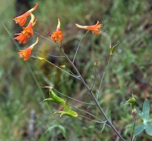
January Plant SalesBy Rosalie Gonzales At this time of year many plants are not looking their best. Below are three different plants featured this month. They are looking particularly nice right now. Plant sales are held Wednesdays, 10:00 a.m.- 12:00 noon, and the first Saturday of every month, 10:00 a.m. - 2:00 p.m. Here is the current inventory. Delphinium nudicaule D. nudicaule is known as Red larkspur or Orange Larkspur. Because our plants are hybrids, we can’t be sure of the color of the blossoms. They might or might not be red or orange. D. nudicaule is known to hybridize easily.
|
|
Delphinium are pollinated by hummingbirds and the flowers are usually born on long thin stems.The plants we have for sale are very healthy looking right now, with bright green dissected leaves with distinctive white/yellow spots. They have not bloomed as yet, and probably won’t bloom until Spring. Add a little mystery to your garden! Photo: D. nudicaule by Dave Matson. |
|
|
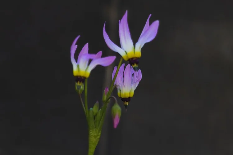
Primula clevelandii var. insularis Shooting Star, formally known as Dodecatheon clevelandii ssp. insularis, is a perennial herb that grows naturally in Southern and Central California and on the Channel Islands. It tends to grow in grassy places. Flowers can vary from purple to white. Photo: Primula clevelandii var. insularis by Sandy Steinman. |
|
|
|
|
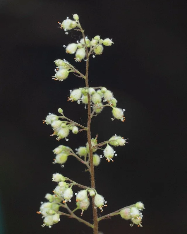
Heuchera maxima Island alum root (Heuchera maxima) is a perennial plant in the saxifrage family. It can serve as a ground cover with attractive foliage and small, pink/white flowers that rise about 12 inches or more above the leaves. It needs full sun to part shade in coastal gardens, and probably would do best in full shade inland. It grows naturally only on the Channel Islands off the coast of Southern California, but adapts well in cultivation. Photo: Heuchera maxima by Sandy Steinman. |
|
|
|
Rosalie Gonzales is a docent and volunteer propagator at the RPBG.
|
Free Garden ToursYou're invited to our free, docent-guided tours every weekend and on Park District holidays: Saturdays and Park District holidays at 2:00 p.m., and Sundays at 11:00 a.m. and 2:00 p.m. Stop by the Greeter Table to pick up Treasure Hunt and I-Spy games for the kids! There will be a 2:00 p.m. tour on Monday, January 19, 2026, the Dr. Martin Luther King, Jr. holiday. Meet at the Visitor Center, no need to sign up. Please remember, if it's raining, we'll have to cancel. Directions to the Garden. Below are a few of the Garden’s winter features. Photos by Sandy Steinman.
|

|
|
Mt. Tranquillon Ceanothus (Ceanothus papillosus var. roweanus). |
|
|
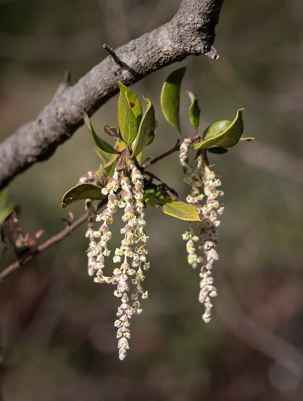
Veatch Silk Tassel (Garrya veatchii). |
|
|
|
|

|
|
Little Sur manzanita (Arctostaphylos edmundsii). |
|
|
Laguna Mountain alumroot (Heuchera brevistaminea). |
|
|

|
|
|
|
|



